|
|
|
MODIS High-Resolution Diffuse Attenuation Coefficient at 490 nm (Kd490)
for Coastal & Turbid Water
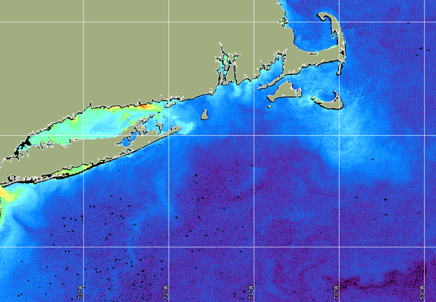
Figure: MODIS High-resolution Coastal Kd490, April 9, 2017, 250 m
The diffuse attenuation coefficient in water indicates how strongly
light intensity at a specified wavelength is attenuated within the water
column. This parameter has wide applicability in ocean optics,
as it is directly related to the presence of scattering particles in
the water column, either organic or inorganic, and thus is an
indication of water clarity.
The diffuse attenuation coefficient at 490 nm (Kd490) indicates the
turbidity of the water column - how visible light in the blue to green
region of the spectrum penetrates within the water column. The value
of Kd490 represents the rate which light at 490 nm is attenuated with
depth. For example a Kd490 of 0.1/meter means that light intensity will
be reduced one natural log within 10 meters of water. Thus, for a Kd490
of 0.1, one attenuation length is 10 meters. Higher Kd490 value means
smaller attenuation depth, and lower clarity of ocean water.
CoastWatch provides high-resolution Kd490 products in near-real time from the
Moderate Resolution Imaging Spectroradiometer (MODIS) on-board the
NASA Earth Observing System (EOS) Aqua satellite. This high-resolution Kd490
is well-suited to characterize turbidity in coastal and high-turbid water
(Tomlinson et al, 2019).
It utilizes the 250 m bands on MODIS to achieve the high spatial resolution
rather than the 1 km spatial resolution of other MODIS Kd490 products.
Surface reflectance (rho_s) from MODIS bands 1 (red), 2 (near infrared) and
3 (blue) are used to derive Kd490 using the following difference ratio
technique developed by
NOAA's National Ocean Service: ( Red - NIR ) / ( Blue - NIR ). A red/blue
ratio is often used to estimate Kd490 in coastal turbid waters. A correction
factor is also applied to adjust the resulting difference ratio to coastal
water.
Update:
This product has been compared with the MODIS 1 km
coastal/turbid Kd490 product, and a scaling equation was added to this product
to more closely match this product (Kd250) with the MODIS 1 km coastal/turbid
Kd490 (k490noaa) (Tomlinson et al, 2019).
This change took effect starting with data of April 11, 2018 (2018 day 101).
Because this algorithm applies to coastal and turbid water, it is not
applicable in low-turbid environments. Kd490 values lower than 1.0/meter
are not considered valid. Data files are only available for the
U.S. east coast from Virginia to Maine.
Data Access
- See the Data Access page for
data offerings by region.
- Or use Direct Download to retrieve files
by time-interval and region:
HTTP,
FTP
Reference:
Tomlinson, M.C., R.P. Stumpf, and R.L. Vogel. 2019.
Approximation of Diffuse Attenuation, Kd, for MODIS High-resolution Bands,
Remote Sensing Letters, Vol. 10, No. 2, pp. 178-185.
|