 |
|
OLCI Diffuse Attenuation Coefficient at 490 nm (Kd490)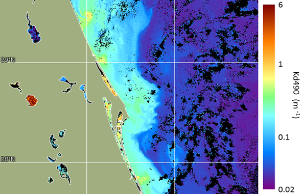
Figure: OLCI Kd490, Florida East Coast at Cape Canaveral, October 16, 2017, 300 m The diffuse attenuation coefficient in water indicates how strongly light intensity at a specified wavelength is attenuated within the water column. This parameter has wide applicability in ocean optics, as it is directly related to the presence of scattering particles in the water column, either organic or inorganic, and thus is an indication of water clarity. The diffuse attenuation coefficient at 490 nm (Kd490) indicates the turbidity of the water column - how visible light in the blue to green region of the spectrum penetrates within the water column. The value of Kd490 represents the rate which light at 490 nm is attenuated with depth. For example a Kd490 of 0.1/meter means that light intensity will be reduced one natural log within 10 meters of water. Thus, for a Kd490 of 0.1, one attenuation length is 10 meters. Higher Kd490 value means smaller attenuation depth, and lower clarity of ocean water. CoastWatch provides Kd490 products in near-real time from the Ocean and Land Colour Instrument (OLCI) on-board the European Sentinel-3 satellites, courtesy of the European Union's Copernicus satellite program. These data offer a spatial resolution advantage over other satellite missions because of their 300 m spatial resolution, as opposed to a typical 1 km spatial resolution of ocean color products from other satellite sensors. Sentinel-3 is a multi-instrument and multi-satellite mission to measure sea- and land-surface temperature, ocean and land color and sea-surface topography. Sentinel-3A was launched on 16 February 2016. Sentinel-3B was launched on 25 April 2018 with the same instruments. See the European Space Agency (ESA) Sentinel-3 website for more information. The Sentinel-3 satellites have a mid-morning local overpass time (roughly 10 AM local time). The Ocean and Land Colour Instrument (OLCI) is based on heritage from ESA's Envisat satellite Medium Resolution Imaging Spectrometer (MERIS) to measure visible and thermal infrared radiances. OLCI has 21 bands at wavelengths from 400 nm to 1020 nm, a spatial resolution of 300 m, and a swath width of 1270 km. With both Sentinel-3 satellites in orbit, the combined swath width of the two OLCI instruments allows near global coverage to be obtained on a daily basis. Kd490 is generated using the MERIS 1999 Baseline Atmospheric Correction and the European OLCI M07 Kd490 algorithm. CoastWatch converts ESA's Kd490 swath data (Level-2) into mapped gridded files (Level-3), including mapped swaths and daily composites. Water reflectances at green and blue wavelengths are within 2% between Sentinel-3A/OLCI and Sentinel-3B/OLCI due to application of traceable and consistent vicarious calibration gains to mitigate radiometric bias between the two sensors. In addition, water reflectances at green and blue wavelengths are within 5% of mission requirement based on comparison with coastal AERONET-OC measurements. Other bands have higher uncertainties and/or are dependent on a water type (EUMETSAT, 2021). However, no in situ validations are available for Kd490. As such, users are cautioned that Kd490 values from OLCI may be inaccurate, particularly in coastal zones. Data representing the above quality begin in near real-time operational processing on 16 February 2021 (i.e. Collection 3). Earlier data will be of lesser quality. Reprocessing of OLCI-A and -B mission data from the start of the time series (to ensure consistent quality across the time series) is in preparation by EUMETSAT. Please consult the EUMETSAT Ocean Colour Services website for the most recent OLCI Level-2 Ocean Colour Product Notice and Collection Report for important ocean color quality information.Data Access
Reference: |
|