NOAA CoastWatch East Coast Node
Data Types Info Data Types: SST         - AVHRR                 - AVHRR-VIIRS                 - Geo-Polar Blended                 - PODAAC MUR Chl-a       - MODIS                 - OLCI (HiRes)                 - VIIRS Clarity     - K490 (MODIS)                 - K490 (MODIS HiRes)                 - K490 (OLCI HiRes)                 - K490 (VIIRS)                 - Rrs667 (MODIS)                 - Rrs672 (VIIRS)                 - TSM (MODIS HiRes)                 - TSM (OLCI HiRes)                 - TSM (VIIRS HiRes) True Color (VIIRS)
Data Access Info HTTP Rolling Archive FTP Time Series Archive
Region Info Regions: U.S. East Coast North East Coast Gulf of Maine Massachusetts & RI Bays Mid-Atlantic Coast NY-NJ Bight & Long Island Sound Chesapeake & Delaware Bays South East Coast Carolina Coast Florida - Georgia Coast
CoastWatch Utilities Time Series Tool ERDDAP MGET Experimental Algal Bloom Monitor


VIIRS True Color Satellite Images

NOAA CoastWatch produces near real-time true color satellite images for U.S. coastal regions from the Visible Infrared Imaging Radiometer Suite (VIIRS) on-board the polar-orbiting Suomi-NPP satellite.

True color satellite images are like a camera photo. The instrument's visible measurements at the red, green, and blue wavelengths are combined to create a color-realistic image, just like a digital photograph. Land and water features can be seen in these images. Because cloud coverage is very obvious, these images can be used to quickly determine if a particular day's image is useful for observing a land or water feature.

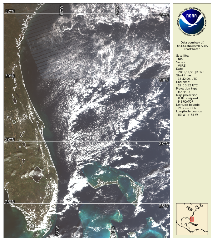
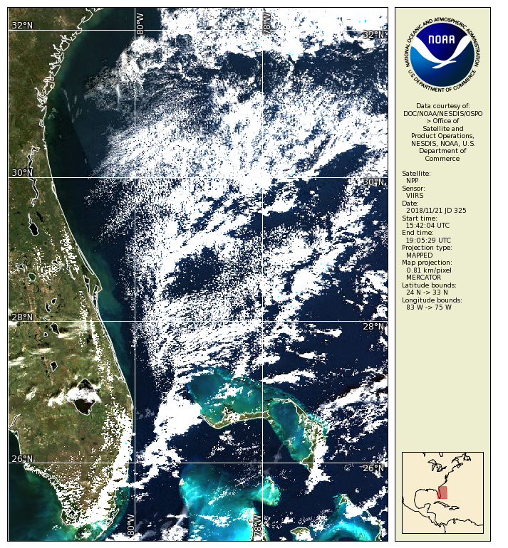
CoastWatch generates data files of both top-of-atmosphere radiance and surface reflectance of the VIIRS red, green and blue bands. The surface reflectance is corrected for atmospheric effects, such as a Rayleigh correction, whereas the top-of-atmosphere radiance is uncorrected for atmospheric effects. True color made from surface reflectance offers clearer, brighter images. Below is a comparison of the two approaches.

NOAA CoastWatch East Coast Node began featuring true color images made with surface reflectance on November 9, 2018, but then reverted to true color images made with top-of-atmosphere radiance on April 11, 2019. The intention is to again offer true color images made with surface reflectance in the future.

Starting September 14, 2021, an improved image enhancement was implemented to generate true color images from top-of-atmosphere radiance that accentuates coastal in-water features similar to true color images from surface reflectance. However, it is still intended to again offer true color images made with surface reflectance at some point in the future.

True Color from Top-of-atmosphere Radiance
Notice the stripes near the top that are data gaps that arise from pixel aggregation at the edge of the instrument's scan when projected to a geographic grid.
True Color from Surface Reflectance
Stripe artifact corrected. Image is brighter and clearer due to atmospheric corrections.
S-NPP VIIRS top of atmosphere image from Nov 21, 2018
S-NPP VIIRS surface reflectance image from Nov 21, 2018
November 21, 2018, S-NPP/VIIRS

Data Access
  • See the Data Access page for data offerings by satellite, data-type, or region.
  • Or use Direct Download to retrieve files by time-interval and region: HTTP, FTP


link to DOC home page

The NOAA CoastWatch East Coast Regional Node is hosted within the National Ocean Service and the NOAA Chesapeake Bay Office.
NOAA is an agency in the Department of Commerce (DOC).

Search | Customer Survey | Contact Us | Links & Site Map
Privacy Policy | Information Quality | Accessibility | Link Disclaimer

link to NOAA home page
 
NOAA Home Page NOAA CoastWatch East Coast Node