 |
|
New York - New Jersey Bight & Long Island Sound Satellite Data
Data Descriptions and Download Links
SATELLITE IMAGE
CHLOROPHYLL
WATER TEMPERATURE
Satellite Daily Image
select date:
Chlorophyll Daily Image
select date: 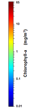
Surface Water Temperature Daily Image
select date: 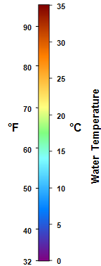
Water Temperature
AVHRR
Surface water temperature from NOAA's Advanced Very High Resolution
Radiometer (AVHRR). Overpasses from all operating AVHRR instruments are
averaged into daily, 3-day, 7-day, monthly, seasonal and annual composites
(composite includes day and night overpasses).
Spatial resolution is nominally 1 km.
More information
AVHRR-VIIRS Multisensor
Surface water temperature combined from the Advanced Very High Resolution Radiometer (AVHRR) and the Visible Infrared Imaging Radiometer Suite (VIIRS).
Overpasses from all operating AVHRR and VIIRS instruments are averaged into
daily, 3-day, 7-day, monthly, and seasonal composites (nighttime only).
Spatial resolution is nominally 750 km.
More information
Chlorophyll-a
MODIS
Chlorophyll-a from the Moderate Resolution Imaging Spectroradiometer (MODIS)
onboard the NASA Aqua satellite, processed using the NOAA OC3 algorithm with
the combined NIR-SWIR atmospheric correction (NOAA OC3 NIR-SWIR).
More information
OLCI
Chlorophyll-a from the Ocean and Land Colour Intrument (OLCI) onboard the
European Sentinel-3A and 3B satellites, courtesy of the European Union's
Copernicus satellite program. The data are processed with the European
Space Agency's ocean color 4-band combination chlorophyll-a algorithm (OC4ME)
and the MERIS 1999 Baseline Atmospheric Correction.
More information
VIIRS
Chlorophyll-a from the Visible Infrared Imaging Radiometer Suite (VIIRS)
onboard the Suomi-NPP satellite, processed with the NOAA OC3 algorithm
(Wang et al., 2017) and the NIR atmospheric correction of Jiang & Wang
(2014).
More information
Diffuse Attenuation Coefficient at 490 nm
Diffuse Attenuation Coefficient at 490 nm (Kd-490) measures how strongly light intensity at the specified wavelength (490 nm) is attenuated within the water column. It is a measure of the water's turbidity. MODIS (NASA "KD2" algorithm, 1 km)
MODIS (NOAA/NESDIS algorithm, 1 km)
MODIS (NOAA/NOS algorithm, 250 m)
OLCI (ESA M07 algorithm, 300 m)
VIIRS (NOAA/NESDIS algorithm, 750 m)
Sediment Index (Remote Sensing Reflectance at red wavelengths)
The remote sensing reflectance (Rrs) in the red wavelengths can be used as a surrogate for sediment concentration in the surface water. As the sediment load in the surface water increases, the reflectance in the red wavelengths will increase. Since the Rrs values are reflectance measurements and not sediment concentration measurements, only relative amounts of sediment in the water may be inferred. Higher Rrs values indicate relatively more suspended sediment compared to lower Rrs values. Patterns of suspended sediment distribution, both spatial and temporal, and sediment gradients may be detected and monitored. MODIS (Rrs at 667 nm)
VIIRS (Rrs at 672 nm)
Total Suspended Matter
Total suspended matter (TSM) is a measure of the concentration of particulate material in the surface water such as mud, silt, and other fine-scale debris, including both organic and inorganic fractions. OLCI
True Color
True Color satellite image data from the Visible Infrared Imaging Radiometer Suite (VIIRS) at 750 m spatial resolution. Data files contain red, green and blue radiance data; images are also available. More information
East Coast Node filenaming convention Data citation: Please acknowledge "NOAA CoastWatch/OceanWatch" when you use data from our site and cite the particular dataset DOI as appropriate. |
|